|
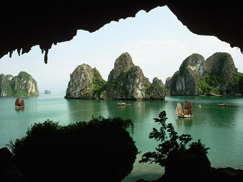
Ha Long Bay (Vietnamese: Vịnh Hạ Long, literally: "descending dragon bay") is a UNESCO World Heritage Site, and a popular travel destination, located in Quang Ninh province, Vietnam. Administratively, the bay belongs to Hạ Long City, Cẩm Phả town, and part of Van Don district. The bay features thousands of limestone karsts
and isles in various sizes and shapes. Ha Long Bay is a center of a
larger zone which includes Bái Tử Long bay to the northeast, and Cát Bà
islands to the southwest. These larger zones share similar geological, geographical, geomorphological, climate, and cultural characters.
Ha Long Bay has an area of around 1,553 km2, including 1,960–2,000 islets, most of which are limestone. The core of the bay has an area of 334 km2 with a high density of 775 islets.
The limestone in this bay has gone through 500 million years of
formation in different conditions and environments. The evolution of the
karst in this bay has taken 20 million years under the impact of the tropical wet climate. The geo-diversity of the environment in the area has created biodiversity, including a tropical evergreen biosystem, oceanic and sea shore biosystem. Ha Long Bay is home to 14 endemic floral species and 60 endemic faunal species.
|
La
Baia di Ha Long (vietnamita:
Vịnh Hạ Long) è un'insenatura situata nel golfo del Tonchino, in territorio vietnamita. Fa parte della provincia di Quang Ninh e comprende circa 3000 isolette calcaree con numerose grotte carsiche. La baia si trova 164 km ad est della capitale Hanoi, non lontano dal confine con la Cina. In lingua vietnamita il termine "Hạ Long" significa "dove il drago scende in mare". Dal 1994 è un patrimonio dell'umanità dell'UNESCO.
Secondo gli scienziati Ha Long è stata sottoposta almeno 500 milioni di anni fa a vari stati geologici di orogenesi, innalzamento e diminuzione del livello marino. Durante l'Ordoviciano ed il Siluriano (500-410 milioni di anni fa) Ha Long si trovava in mare aperto. Nel Carbonifero e nel Permiano (340-250 milioni di anni fa) raggiunse il livello del mare.
A causa dello spesso livello di calcare, di un clima caldo-umido e del lento processo tettonico, Ha Long ebbe un'evoluzione carsica che durò 20 milioni di anni, e si formarono numerose grotte.
 |
Hạ Long Bay has experienced at least 500 million years in various geological states of orogeny, marine transgression and marine regression. During the Ordovician and Silurian periods (500-410 million years ago), Hạ Long Bay was deep sea. During the Carboniferous and Permian periods (340-250 million years ago), Hạ Long Bay was at shallow sea level.
Due to a simultaneous combination of ideal factors such as thick,
pale, grey, and strong limestone layers, which are formed by
fine-grained materials; hot and moist climate and slow tectonic process
as a whole; Hạ Long Bay has had a complete karst evolution for 20
million years. There are many types of karst topography in the bay, such as karst field.
|
Una leggenda locale dice che molti anni fa i vietnamiti stavano
combattendo gli invasori cinesi; gli dei mandarono una famiglia di
dragoni per aiutarli. Questi dragoni iniziarono a sputare gioielli che
si trasformarono nelle isole ed isolotti che punteggiano la baia,
unendoli poi per formare una muraglia contro gli invasori. Le persone
salvarono la propria terra e la trasformarono in quello che poi sarebbe
diventato il Vietnam. Il luogo in cui atterrò il dragone madre venne
chiamato Hạ Long, il luogo in cui arrivarono i figli prese invece il
nome di Bái Tử Long
(Bái: essere al seguito di, Tử: figli, Long: dragone), ed il posto in
cui i figli agitarono violentemente le proprie code venne chiamato Bạch
Long Vỹ (Bạch: colore bianco della schiuma, Long: dragone, Vỹ: coda).
 |
Timeline of geologic evolution
Some of the most remarkable geological events in Hạ Long Bay’s
history have occurred in the last 1,000 years, include the advance of
the sea, the raising of the bay area, strong erosion that has formed
coral, and, pure blue and heavily salted water. This process of erosion
by seawater has deeply engraved the stone, contributing to its fantastic
beauty. Present-day Hạ Long Bay is the result of this long process of
geological evolution that has been influenced by so many factors.
Due to all these factors, tourists visiting Hạ Long Bay are not only
treated to one of the natural wonders of the world, but also to a
precious geological museum that has been naturally preserved in the open
air for the last 300 million years.
| Date |
Geologic period |
Events |
| 570,000,000-500,000,000 BC |
beginning of the Cambrian era |
The area, which now forms Hạ Long Bay, was basically mainland, submitted to a process of rain erosion. |
|
end of the Cambrian period |
The area was flooded, commencing the existence of Hạ Long Bay. |
| 500,000,000-400,000,000 BC |
Ordovician and Silurian periods |
The area of north-east Vietnam was basically a deep sea, submitted to the constant activity of tectonic plates. |
|
end of the Silurian period |
It underwent a phase of inverse-motion that created mountains deep under the water. |
| 420,000,000-340,000,000 BC |
end of the Silurian period and throughout the whole Devonian period |
The area was subjected to powerful forces of erosion from the hot
and dry climate. At this point, Hạ Long was part of a wide mainland that
comprised most of today's East Sea and Chinese continental shelf. |
|
end of the Devonian period |
Due to tectonic activity, the Hạ Long area and the entire north-east region were raised from the depths |
| 340,000,000-240,000,000 BC |
later Carboniferous and Permian periods |
The formation of the limestone layer more than 1,000 m thick. A
shallow and warm sea reformed, which existed for approximately 100
million years. It created two kinds of limestone: the Cát Bà layer of
the early Carboniferous period (450 m thick); and the Quang Hanh layer
of the middle Carboniferous and the early Permian period (750 m thick).
These two layers constitute the majority of the islands of the Bay. |
| 67,000,000 BC |
end of the Cretaceous period |
Hạ Long Bay existed in the environment of a high mountainous mainland due to the influence of strong mountain-forming phases. |
|
middle of the Paleocene period |
These motions remain continuous and stable, while strong processes
of erosion began, and after millions of years, a form of semi-highland
topography took shape. The continuation of this erosion has
progressively cut the highlands into blocks with altitudes similar to
today's mountains |
| 26,000,000-10,000,000 BC |
Neogene period |
The development of the Hạ Long depression |
| 2,000,000-9000 BC |
Pleistocene epoch of the Quaternary period |
The process of erosion began dissolving the limestone-rich region of
Hạ Long, after that, forming the limestone plain was most active |
| 68,000-9000 BC |
middle and late Pleistocene epoch |
Period when the caves and grottoes of the area formed. |
|
early Holocene period |
The islands of today’s Hạ Long Bay are basically remnants of these
mountains, flooded. Rainwater flowed into crevices in the limestone that
had formed from tectonic activity. This steady erosion constantly
widened the cracks, eventually creating today's formations. |
| 9000-5000 BC |
Holocene period |
This period is notable for the advance of the sea. |
| 5000-2000 BC |
|
The movement of the sea reached its peak and forming today’s Hạ Long Bay. |
| 2000-1000 BC |
|
With the sea in a steady process of recession, Hạ Long culture began to develop. |
|
beginning of the late Holocene epoch |
The level of the water once again increased, forming a marshy floor
of canals and streams, and creating the water marks that can be seen on
the stone cliffs of today. |
|
La baia di Ha Long si trova nel Vietnam Nord-orientale, tra le longitudini 106°56' e 107°37' Est e le latitudini 20°43' e 21°09' Nord. La baia si trova nel distretto di Yên Hưng, tra la città di Hạ Long e Cẩm Phả, fino al distretto di Vân Đồn, confina a sud e a sud-est con il golfo del Tonchino, a nord con la Cina e ad ovest e sud-ovest con l'isola di Cat Ba.
La baia occupa 120 km di costa e copre un'area di circa 1553 km², con
circa 1969 isolotti. L'area protetta dall'UNESCO comprende circa 434 km²
e 775 isole, il cui nucleo è delimitato da 69 punti: l'isola di Đầu Gỗ ad ovest, il lago Ba Hầm a sud e l'isola Cống Tây ad est. L'area protetta va dal deposito di carburante di Cái Dăm al comune di Quang Hanh.